The scenic drive through the Tiger Mountain foothills in King County, Washington, attracts travelers because it combines forested backroads, changing elevation zones, Cascade foothill scenery, and accessible pull-off viewpoints within a short distance of Seattle. The region surrounding Tiger Mountain offers a balanced road trip experience with winding forest corridors, seasonal color changes, photography stops, and connections to nearby outdoor recreation areas across the Snoqualmie Valley and Issaquah Alps region.
Why Does the Scenic Drive Through Tiger Mountain Foothills Stand Out in King County?
The Tiger Mountain foothills area stands out because it creates a transition zone between urban King County communities and the western slopes of the Cascade Mountains. Drivers moving through the corridor experience gradual elevation changes, dense evergreen forest, roadside creeks, and panoramic openings that reveal valleys, ridgelines, and layered mountain terrain.
The drive commonly begins near Issaquah and extends through sections connected to Tiger Mountain State Forest, the Issaquah-Hobart Road corridor, and surrounding foothill roads leading toward North Bend. Unlike heavily commercialized scenic routes, the Tiger Mountain foothill drive remains primarily nature-focused, which supports traveler intent centered on peaceful exploration, roadside photography, and forest immersion.
The foothill geography contributes significantly to the route’s appeal. Western lowlands near Issaquah quickly transition into elevated forest ridges, moss-covered terrain, and conifer-dominated ecosystems associated with the Cascade foothills. This environmental layering creates visual variety throughout the drive without requiring long-distance travel.
Travelers frequently choose this route for day trips because it combines accessibility with wilderness atmosphere. Roads remain close enough to Seattle metropolitan areas for short excursions while still providing a distinctly remote visual experience.
What Is the Best Driving Route Through the Tiger Mountain Foothills?
One of the most effective scenic driving structures begins in downtown Issaquah before connecting to the foothill roads surrounding Tiger Mountain. Starting near Lake Sammamish allows drivers to gradually transition from suburban landscapes into heavily forested elevation zones.
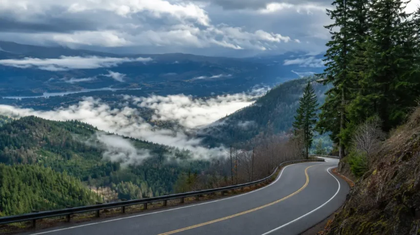
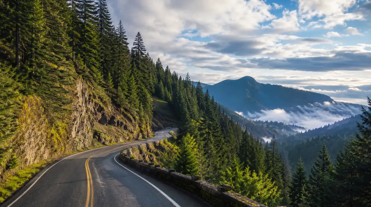
The route typically follows Issaquah-Hobart Road Southeast toward the southern foothill sections near Tiger Summit. This corridor provides consistent scenery changes, including cedar forest sections, narrow valleys, elevated ridgelines, and occasional openings toward the Snoqualmie Valley.
Drivers seeking longer scenic coverage often continue toward North Bend through connecting rural roads. This extension introduces broader Cascade foothill scenery, open meadow transitions, and distant mountain visibility during clear weather conditions.

Several smaller connecting roads near the Tiger Mountain area enhance the exploratory nature of the drive. Local forest access roads and pull-off zones create opportunities to pause without fully committing to hiking trails. These transition areas are especially valuable for photographers seeking layered forest compositions and elevation-based landscape views.
The route also benefits from relatively moderate driving difficulty compared to high mountain passes. Most roads remain accessible throughout much of the year, making the area attractive for travelers seeking scenic forest driving without alpine-level conditions.
How Do Forest and Elevation Transitions Shape the Visitor Experience?
The driving experience through the Tiger Mountain foothills is strongly defined by ecological transitions. Lower elevation sections near Issaquah contain mixed suburban-greenbelt environments before quickly shifting into dense Pacific Northwest forest systems.
As drivers gain elevation around the Tiger Mountain foothill roads, Douglas fir, western red cedar, and bigleaf maple ecosystems become increasingly dominant. Moisture-rich forest conditions create a characteristic Pacific Northwest atmosphere with ferns, moss-covered tree trunks, and shaded road corridors.
These transitions create changing visual environments within relatively short distances. The road structure alternates between enclosed forest tunnels and broader scenic openings overlooking valleys and ridge systems. During overcast weather, the foothills often develop low cloud layers and mist formations that intensify the scenic character of the drive.
Elevation changes also influence temperature and seasonal conditions. Autumn foliage becomes particularly noticeable in transitional maple zones, while winter months may introduce light snow at higher elevations around Tiger Mountain. Spring produces vibrant greenery and roadside wildflower growth, especially near creek corridors and forest edges.

Because the drive crosses multiple ecological zones, travelers experience a wider range of visual textures than many standard suburban scenic routes. This layered geography contributes significantly to the route’s popularity among photographers and weekend road trip travelers.
Where Are the Best Scenic Pull-Off Points and Photography Stops Near Tiger Mountain?
Several pull-off areas and roadside openings create strong photography opportunities throughout the Tiger Mountain foothills. Scenic stops are most valuable where elevation changes create broad visibility across valleys and forest ridgelines.
The Tiger Summit area offers elevated perspectives that reveal surrounding foothill geography and portions of the Cascade transition landscape. Morning light conditions often create atmospheric fog layers in nearby valleys, while evening light can illuminate western-facing ridges.
Roadside viewpoints near the Issaquah-Hobart corridor provide access to quieter forest scenery without requiring extended hiking. These sections are particularly attractive for travelers capturing Pacific Northwest forest imagery, including moss-covered trees, narrow forest roads, and seasonal color transitions.
Travelers continuing toward North Bend encounter wider landscape photography opportunities connected to the Snoqualmie Valley. Openings along the drive may reveal distant mountain silhouettes and layered foothill terrain during clear weather.
Photography conditions vary significantly by season. Autumn produces the strongest color contrasts, while winter and early spring create dramatic mist and cloud formations around the foothill ridges. Summer provides the clearest visibility for long-distance landscape compositions, especially during early morning hours.
The route’s photographic appeal also comes from its diversity. Visitors can capture forest interiors, winding road perspectives, elevation overlooks, and valley panoras within a single drive.
When Is the Best Time to Experience the Tiger Mountain Foothill Drive?
The scenic drive through Tiger Mountain foothills changes substantially across the seasons, making timing an important factor for visitors seeking specific landscape conditions.
Spring introduces fresh greenery throughout the foothill forests. Moss becomes more vibrant, roadside vegetation thickens, and rainfall supports dense forest textures associated with western Washington ecosystems. Creek systems near the foothills also appear more active during this period.
Summer provides the most stable driving conditions and highest visibility levels. Clear skies increase long-distance mountain visibility near the Snoqualmie Valley and nearby Cascade foothills. Dry roads also improve access to secondary scenic roads surrounding Tiger Mountain State Forest.
Autumn is often considered the most visually dynamic season for this drive. Bigleaf maple foliage creates yellow and orange color variation among evergreen forest sections. Seasonal contrast between deciduous and coniferous vegetation produces layered Pacific Northwest scenery highly valued by photographers and scenic travelers.
Winter introduces a quieter atmosphere with fog, mist, and occasional snow accumulation at higher elevations. Although visibility may become more limited, the moody forest conditions create a distinct Pacific Northwest driving experience associated with cloud-covered ridges and rain-soaked evergreen landscapes.
Weekday mornings typically provide the calmest conditions for visitors seeking uninterrupted photography opportunities and lower traffic volumes throughout the foothill corridors.
What Nearby Travel Connections Enhance a Tiger Mountain Scenic Road Trip?
The Tiger Mountain foothills connect naturally with several other King County destinations that strengthen the overall travel experience. Nearby areas within the Issaquah Alps and Snoqualmie corridor expand sightseeing opportunities without requiring significant additional travel time.
Travelers frequently combine the drive with visits to Rattlesnake Lake, Snoqualmie Pass, or sections of the Mount Si area. These nearby destinations reinforce the broader Cascade foothill travel theme while introducing additional scenic landscapes and recreational viewpoints.
The drive also complements exploration of rural King County roads surrounding Hobart and Preston, where forested valleys and low-density communities maintain a quieter regional atmosphere compared to urban Seattle corridors.
If you are visiting this area, you may also want to explore: best cafés near the Tiger Mountain trail entrance. This complementary food-focused experience helps travelers locate relaxing coffee stops and casual dining options before or after scenic driving through the foothills. The café-focused content supports traveler intent related to rest stops, local refreshments, and convenient roadside breaks near outdoor recreation areas.
The Tiger Mountain foothill route remains particularly effective for travelers seeking flexible itineraries. Visitors can extend the drive toward mountain viewpoints, shorten the route into a half-day outing, or connect the experience with nearby hiking and sightseeing destinations throughout eastern King County.
How Does the Scenic Drive Support Pacific Northwest Road Trip Experiences?
The Tiger Mountain foothills represent a classic western Washington road trip environment because they combine dense forest ecosystems, elevation-driven scenery, and rapidly changing weather conditions within a compact travel radius.
Unlike desert or coastal scenic routes, Pacific Northwest foothill drives emphasize atmospheric landscape qualities. Fog movement, rainfall patterns, evergreen density, and filtered forest light all shape the visual experience throughout the route.
This environment supports multiple visitor intentions simultaneously. Photographers seek textured forest scenery, casual travelers pursue quiet nature immersion, and regional tourists use the drive as an introduction to Cascade foothill geography near Seattle.
The route’s accessibility also strengthens its regional significance. Travelers do not require advanced mountain driving experience to enjoy the area, yet the visual character remains distinctly wilderness-oriented. This balance contributes to the route’s popularity among weekend visitors exploring eastern King County.
Because the foothill system connects forests, valleys, ridgelines, and nearby mountain corridors, the drive continuously reinforces Pacific Northwest landscape identity. The result is a scenic experience centered on environmental transitions rather than isolated viewpoints alone.
Frequently Asked Questions About the Tiger Mountain Foothill Scenic Drive
What is the scenic drive near Tiger Mountain known for?
The Tiger Mountain foothill drive is known for forested roads, Cascade foothill scenery, elevation changes, scenic pull-offs, and Pacific Northwest photography opportunities near Issaquah in King County, Washington.
How long does the Tiger Mountain scenic drive take?
Most scenic driving routes through the Tiger Mountain foothills take between one and three hours depending on stops, photography breaks, seasonal traffic, and whether travelers continue toward North Bend or Snoqualmie Valley areas.
Is the Tiger Mountain foothill drive good during autumn?
Yes. Autumn is one of the best seasons because bigleaf maple foliage creates strong color contrast against evergreen forests, producing visually dynamic Pacific Northwest scenery throughout the foothill corridors.
Are there scenic viewpoints along the Tiger Mountain roads?
Several roadside pull-offs and elevated openings provide viewpoints overlooking valleys, forests, and nearby foothill ridges. Visibility is often best during summer mornings and clear autumn afternoons.
Can visitors explore the Tiger Mountain foothills without hiking?
Yes. Many travelers experience the region entirely by car through scenic roads, pull-off areas, photography stops, and short roadside viewpoints without entering major hiking trails.
What nearby destinations connect well with Tiger Mountain?
Nearby travel connections include Rattlesnake Lake, Mount Si, Snoqualmie Valley, Snoqualmie Pass, and other Issaquah Alps locations that extend the broader Cascade foothill exploration experience.